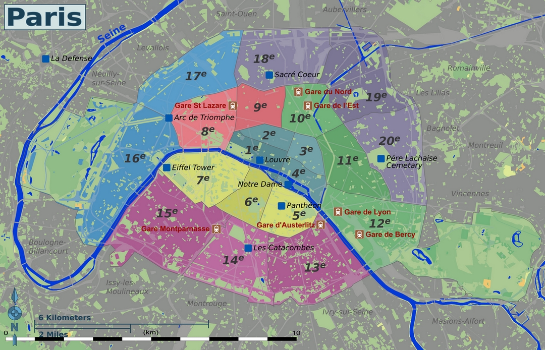
Paris Districts with Map and List
Paris is divided into 20 unique districts called arrondissements, spiraling outwards from the city center (think numbered zones, 1 to 20, going clockwise). Each arrondissement offers its own character and attractions. Free maps from tourist information centers or hotels will help you navigate and discover hidden gems throughout the city. You can see where these districts are on the map below. Below that, you can find the must-see places in these districts. Notably, the 12th and 16th districts boast large parks, Bois de Vincennes and Bois de Boulogne, for those seeking green escapes.

Central Paris (1st arr., 2nd arr., 3rd arr., 4th arr.)
Details…
1e: The geographical centre of Paris and a great starting point for travellers. The Musée du Louvre, the Jardin des Tuileries, Place Vendôme, Les Halles shopping centre, Palais Royal, Comédie-Française, théatre du Châtelet, Arc de Triomphe du Carrousel, and the western half of Île de la Cité (Paris’s largest island).
2e: The central business district of the city — the Bourse (the Paris Stock Exchange), Opéra-Comique, Théâtre des Variétés, Passage des Panoramas, Théâtre des Bouffes Parisiens and the former Bibliothèque Nationale are here.
3e: Archives Nationales, Musée Carnavalet, Conservatoire des Arts et Métiers, Hôtel de Soubise, the former Temple fortress, and the northern, quieter part of the Marais.
4e: Notre-Dame de Paris, the Hôtel de Ville (Paris city hall), Hôtel de Sully, Beaubourg, Rue des Rosiers and the Jewish Quarter, Le Marais, Bazar de l’Hôtel de Ville, Mémorial de la Shoah, Centre Georges Pompidou, l’atelier Brancusi, Place des Vosges, Bibliothèque de l’Arsenal, Saint-Jacques Tower and the Parisian island Île Saint-Louis as well as the eastern half of Île de la Cité.
Left Bank (5th arr., 6th arr., 7th arr.)
Details…
5e: This is the eastern part of the Quartier latin (Latin Quarter). Jardin des Plantes, Muséum National d’Histoire Naturelle, Musée de Cluny, the Panthéon, La Sorbonne, Montagne Sainte-Geneviève, Église Saint-Séverin, La Grande Mosquée, Le Musée de l’AP-HP.
6e: This contains the western part of the Quartier latin. Jardin du Luxembourg as well as its Sénat, Place Saint-Michel, Église Saint-Sulpice and Saint-Germain-des-Prés.
7e: Tour Eiffel and its Parc du Champ de Mars, Les Invalides, Musée d’Orsay, Assemblée nationale and its subset administrations, École Militaire, Musée du quai Branly, and Parisian mega-store Le Bon Marché.
Inner Paris (8th arr., 9th arr.)
Details…
8e: Champs-Élysées, Arc de Triomphe, Place de la Concorde, le Palais de l’Élysée, Église de la Madeleine,Jacquemart-André Museum, Gare Saint-Lazare, Grand Palais, Petit Palais, and the western half of Boulevard Haussman.
9e: Opéra Garnier, Galeries Lafayette, Musée Grévin, Folies Bergère, and the eastern half of Boulevard Haussman.
East Paris (10th arr., 11th arr., 12th arr.)
Details…
10e: Canal Saint-Martin, Gare du Nord, Gare de l’Est, Porte Saint-Denis, Porte Saint-Martin, Passage Brady, Passage du Prado, and Église Saint-Vincent-de-Paul.
11e: The bars and restaurants of Rue Oberkampf, Bastille, Nation, New Jewish Quarter, Cirque d’Hiver, and Église Saint-Ambroise.
12e: Opéra Bastille, Bercy Park and Village, AccorHotels Arena, Promenade Plantée, Quartier d’Aligre, Gare de Lyon, Cimetière de Picpus, Viaduc des arts, the Bois de Vincennes, and the Zoo de Vincennes.
South Paris (13th arr., 14th arr., 15th arr.)
Details…
13e: Quartier Asiatique (Asian Quarter), Place d’Italie, La Butte-aux-Cailles, Bibliothèque Nationale de France (BNF), Gare d’Austerlitz, Manufacture des Gobelins, the Olympiades, the Tolbiac district, Pitié-Salpêtrière hospital.
14e: Cimetière du Montparnasse, Gare Montparnasse, La Santé Prison, Denfert-Rochereau, Parc Montsouris, Stade Charléty, Cité Internationale Universitaire de Paris, and the public entrance to the catacombs.
15e: Tour Montparnasse, Porte de Versailles, Front de Seine, La Ruche, Parc André Citroën, Aquaboulevard and quartiers Saint-Lambert, Necker, Grenelle and Javel.
West Paris (16th arr., 17th arr.)
Details…
16e: Palais de Chaillot, Musée de l’Homme, the Bois de Boulogne, Cimetière de Passy, Parc des Princes, Musée Marmottan-Monet, Trocadéro, Maison de la Radio, and Avenue Foch.
17e: Palais des Congrès, Place de Clichy, Parc Monceau, Marché Poncelet, and Square des Batignolles.
Paris Hills (18th arr., 19th arr., 20th arr.)
Details…
18e: Montmartre, Pigalle, Barbès, Basilica of the Sacré Cœur, Église Saint-Jean-de-Montmartre, and Goutte d’Or can be found here.
19e: Cité des Sciences et de l’Industrie, Parc de la Villette, Bassin de la Villette, Parc des Buttes-Chaumont, Cité de la Musique, Canal de l’Ourcq, and Canal Saint-Denis can be found here.
20e: Cimetière du Père-Lachaise, Parc de Belleville, and quartiers Belleville and Ménilmontant.
La Défense
Details…
Although not officially part of Paris, this rapidly-growing business district lies just west of the city and is on many visitors’ must-see lists for its modern skyscraper architecture and public art.
Beyond central Paris, the outlying suburbs are called Les Banlieues. Schematically, those on the west of Paris (Neuilly-sur-Seine, Boulogne-Billancourt, Saint Cloud, Levallois) are wealthy residential communities. Those to the north are poorer communities, and very ethnically diverse. Those to the south are a mix of rough and poor neighbourhoods alongside very affluent communities. Finally, those to the east are usually lower-middle class mingled with a few upper-middle class communities.
Paris Travel Guide
Be sure to read our updated and comprehensive blog post if you haven’t already.
